


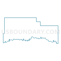
Precinct 24, Roosevelt County, Montana
About
Outline

Summary
| Unique Area Identifier | 612246 |
| Name | Precinct 24 |
| County | Roosevelt County |
| State | Montana |
| Area (square miles) | 0.37 |
| Land Area (square miles) | 0.37 |
| Water Area (square miles) | 0.00 |
| % of Land Area | 100.00 |
| % of Water Area | 0.00 |
| Latitude of the Internal Point | 48.08707350 |
| Longtitude of the Internal Point | -105.64171750 |
Maps


Graphs
Select a template below for downloading or customizing gragh for Precinct 24, Roosevelt County, Montana


Neighbors
Neighoring Voting District (by Name) Neighboring Voting District on the Map
- Precinct 22, Roosevelt County, MT
- Precinct 26, Roosevelt County, MT
- Precinct 27, Roosevelt County, MT